The decision to write All The Oceans was influenced by my involvement with the University of Auckland Engineering Department creating a Masters of Yacht Engineering program. The most frequently asked question from students was “How did you do it?” All The Oceans is my response.
I did not pursue what is now considered the conventional way to become a yacht designer. The combination of a fascination with voyages of exploration under sail, a natural talent for drawing and a three-year apprenticeship in a wood boat fabrication shop laid the foundation for me to strike out on my own. Without hesitation, I grasped every opportunity that came my way.
All The Oceans: Designing by the seat of my pants describes how I did it.
Ron embarked on a nautical journey five decades ago, from his native New Zealand, to numerous stops along the way before settling in Canada. He began his boat design career in San Francisco before spending 40 years in Ireland, where in 1973, he established Ron Holland Design. There he met a Canadian who wanted to return home, and Ron decided that it was time for a change.
As he writes in All The Oceans: “My new office overlooked Coal Harbour, the downtown marina near Vancouver’s main commercial port: through the windows I had a clear view of boats moored at the Royal Vancouver Yacht Club marina, and beyond, of the snow-capped peaks of Cypress Mountain. It’s a dramatic but calming location, and I was looking forward to another phase of my life.”
It was, however, a stressful life, and in 2012 he suffered a stroke. Yet it too opened up new possibilities.
“Thinking it through further, I would do other things with my life, fulfilling long-buried desires. I would read more. I would teach. I would take piano lessons, as I had in my teens with my mother’s encouragement. I would do more drumming, which would also have the bonus of restoring some of the dexterity in my left hand. In short, I would start a new life in Vancouver-and I did,” he recounts in the book.
Ron wrote All The Oceans to inspire others. This latest chapter — settling in Vancouver, BC (where he eventually moved his office to Granville Island from Coal Harbour) was indeed a new start. After writing his memoir, promoting the book would lead him to revisit old haunts all over the world, reconnect with old friends and regale audiences on how he established an award winning international design company also including colourful nautical tales culled from a life of adventure.
This is a short post to lay out some clear answers about CHS (Canadian Hydrographic Service) electronic charts.
Pacific Coast Digital Chartsets
CHS does sell electronic charts- which are available in BSBv3 (unencrypted) Raster and S57 Vector formats. They are available for the Great Lakes, Pacific Coast, Atlantic Coast, and Arctic. These charts are not available on CD, but must be downloaded. Users purchase access to these charts from a chart agents (like our store), and once we process your order, we will provide you with a transaction code and how-to guide so that you can access your charts and download them onto a computer or other device. Most important, however, is that you don’t need to use the windows executable that comes with the downloaded charts in order to read them- as long as the plotting software you have can read BSB3 or S57 charts.
The Great Lakes digital chart setsAtlantic Coast Digital Chartsets
You will need Chart plotting or navigation software to then load and use the charts- we suggest OpenCPN. Other options include INavX, which is available for both iOS and Android, and so can be used on iPads and other hand-held devices.
Now that Spring has Sprung, it’s time for our annual CHARTS! post.
In the past, a number of blogs have been written about charts: what we carry, what we can order, and laws regarding charts. We’re proud to be a chart agent, providing Canadian Hydrographic Services charts, as well as charts from NOAA, Imray, Maptech, Richardson’s, NV Charts, and a number other organizations and companies. There continues to be some confusion over charts, specifically the legality of chartbooks and what is required.
Since this is something that confuses many people:
Small Scale = Large Area
Large Scale = Small Area
To put it another way, if you’re boating around Toronto Harbour, you’ll be required to carry chart 2085- Toronto Harbour. Chart 2077 (Lake Ontario West End) or 2000 (Lake Ontario general) would not be considered to have sufficient information.
The Canada Shipping Act requires most vessels to carry paper charts specifically, even if navigation will be done by GPS or on a computer. If you’re are going to be navigating, you should be carrying charts.
There have also recently been more questions about the legality of chartbooks, such as Richardson’s, Mapquest, and NV-Charts. These are not technically charts, but instead are very high quality photographs of charts. From discussions with representatives of various law enforcement agencies it is clear that there is no universal policy towards chart books. Anecdotal evidence suggests that also, reaction will vary from officer to officer. While the odds suggest that any individual person or boat may not be stopped by the Police or Coast Guard, and even if they were a chartbook such as Maptech or Richardson’s would usually be considered sufficient, they do not technically satisfy the legal requirement to carry charts in Canada.
The reality is that chartbooks such as Richardson’s are much easier to use on a chart table than a full paper chart, and that chartbooks are much more cost efficient than purchasing a full set of paper charts. We also understand that cost is a major factor for choosing to purchase chartbooks only, and not paper charts. What we would suggest is that our clients purchase a chartbook such as Richardson’s for their day-to-day navigation requirements, but also purchase the CHS charts they need to cover their usual cruising areas. To do so is more expensive, but it will cost far less than the fines for not carrying paper charts.
Charts are just part of what is required to be carried on board. It is always necessary to update charts or chartbooks with the Notices to Mariners. In addition, boats are required to have Chart One, Sailing Directions,Tide & Current Tables, the List of Lights, and Buoys and Fog Signals.
If you’ve talked to us about charts- you know that we place a strong emphasis on paper charts, whether they be CHS, NOAA, Imray, Explorer or anything else. Digital Charts cannot be denied, however. In Canada, it is still required to carry paper charts, even if you have digital charts. If you would like to purchase digital Canadian Hydrographic Service charts, we can absolutely provide them to you.
There are a bevy of options when buying charts. Keep on reading for some information on the differences between the charts we carry, and things to consider when making a decision about which charts to purchase. In this blog, I’ll discuss the various types of charts that we carry and some of the advantages and disadvantages of each. I’ll start by considering specific regions. However, what needs to be stated up front is that despite everything mentioned below, the first priority is that you feel comfortable reading your charts, and can understand them.
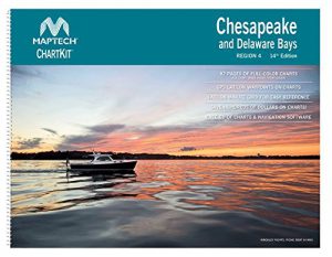
The Great Lakes
In the Great Lakes, there are two broad categories of charts: First, the Canadian Hydrographic Service and NOAA (US) charts, and second the Richardson’s Chartbooks.
The Official Charts
Published by the CHS and NOAA, these are “proper” charts.
PROS
These are the official charts, and strictly satisfy the requirements (under Canadian law) for carrying charts
Individually, CHS charts are relatively inexpensive as most cost approximately $22.60 ($20 with taxes).
These are absolutely readily available in large numbers (with a few days advanced notice
These are up to date- most CHS or NOS charts don’t remain in our chart table for more than a few months
CONS
When buying multiple *different* charts, this can get fairly expensive- a complete set of the Canadian and US Charts for Lake Ontario would cost approximately $1000.
These are huge, when unfolded- 85cm by 120cm- and can be unwieldy to deal with. (This is for *standard* charts- strip charts and Chart 2201 (Georgian Bay General) are different dimensions. NOS charts, however, come in a number of different dimensions (but all relatively similar) this makes working with charts on small chart tables very difficult.
These are very high quality photographs of the US and Canadian charts. You can lay them on top of each other for comparison purposes
In terms of form factor, these are much easier to use in a canoe, kayak, or small yacht/cruiser where table space is at a premium
They reduce some of the double-coverage that can happen in charts (At the same scale), so there is less actual paper involved
They make it quite clear how to progress from one chart to the next
a Richardson’s Chartbook is substantially cheaper than buying the equivalent amount of information in “Proper” charts- for Lake Ontario, a saving of something on the order of 85%
It is possible to purchase a vinyl cover for them to keep them dry when using them
CONS
It can be tedious to bring Chartbooks up to date according to Notices to Mariners
They can be somewhat visually busy and confusing.
The Richardson’s Hudson River/ New York Canal Systems is designed for a voyage from New York City to Owsego/Buffalo/Montreal, so it can be confusing if you’re travelling the other way.
They are marked *NOT FOR NAVIGATION*, which means that if something goes wrong, they can’t be sued. This can be disconcerting to some.
Other Great Lakes/North American Charts
For the other common cruising areas within North America, you can purchase NOAA charts (which are same as above), Waterproof Charts, or Maptech Chartbooks.
Waterproof Charts
PRO
These charts cover much of the US East Coast, as well as parts of the Caribbean Sea
They are actually water-resistant, which makes them really good for using in the cockpit
The paper is a lighter weight than standard charts, and so are easier to use and store.
They very much focus on the areas that matter to cruisers- and so for example will have much less open ocean than a comparable NOAA chart. For example, the image to the left is of Cape May to Sandy Hook
The visual design is very clear- for example the way to transition between panels on the Hudson Rive chart is more clear than the comparable Richardson’s chartbook.
These charts often are on the front and on the back, and can have both large and small scale charts on the same sheet.
CON
If you purchase these charts, it is especially important to make sure that you update them to the most recent Notices to Mariners- although because of the surface of the paper it makes it more difficult to update than NOAA charts.
These charts are ~$40 CAD including taxes, and so if you’ll be transiting large areas it may be more cost efficient to go with a chart book
These charts really do often stick close to shore along the ICW, so if you plan on going further offshore you’ll need to purchase other charts
Maptech Charts
PROS
These charts are made by the same company as Richardson’s, so they the produce of a similar process create from taking NOAA data.
They’re very good for cruisers who want to explore an area as they provide passage charts, inshore charts and harbour charts
The whole series can also provide continuity as cruisers continue to travel the US East Coast
There are also chartbooks for the US West Coast
They come in a heavy duty plastic cover for protection, which can also be used to keep them dry in the cockpit.
CONS
There is an element of sticker shock- these chartbooks can cost approximately $190 CAD, which seems like a lot although it is considerable savings compared to purchasing individual charts
These chartbooks are relatively heavy- approximately twice the size of a Richardson’s they require more storage space
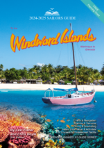
The Caribbean
There are a number of charts options for the Caribbean as well. For example, the Waterproof Chart series mentioned above continues down past Florida to the Mona Passage, Puerto Rico and the Bahamas, and has a good general chart. We have several options that mainly deal with the Caribbean.
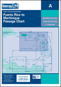
Imray
PROS
Imray is a hugely important company for cruisers- their cruising guides and pilots are the gold standard, and often refer to their charts.
Imray charts are single page- sometimes back and front, for example A233, which combines charts A231 and A232 to cover all of the Virgin Islands
These charts (like the Waterproof charts) are relatively light, and so can be stored easily- they fold down to a A4 size. Likewise, they each come with a heavy plastic cover to protect them
Imray covers much of the world- for example the Mediterranean as well, and so can provide consistency for longer voyages and trips.
CONS
These charts are ~$40 each, and so to cover a large area will be relatively expensive
Imray charts are based on older data- in some cases dating back to the early 20th century- and so are less up to date than other chart series.
NV Charts
PROS
These are similar to Richardson’s/Maptech in terms of the benefits of a chartbook
They do come with electronic charts- which either are on a CD or can be downloaded.
Recently NV Charts has switched many of its editions to ‘Atlas’ format, which stores as effectively half the size of a Maptech chartbook or similar to a Richardson’s chartbook.
These chartbooks contain planning charts, harbour charts and coastal charts
they provide GPS waypoints and are designed to be used with electronic navigation as well
CONS
Again, like with Maptech, there is the sticker shock. These chartbooks are more expensive than getting a small number of Imray charts
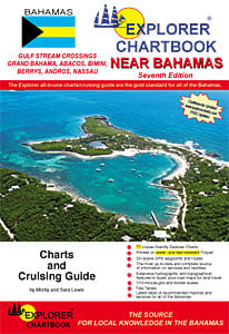
Explorer Chartbooks
The Explorer Chartbooks are the gold standard for Bahamas charts. They are the most up-to-date, and most accurate. They are divided into the Near Bahamas, Far Bahamas and Exumas. These are a very different style to the NV Charts or Imray charts- but they are created by experienced cruisers for cruisers. They are printed on tear and water resistant paper. In addition to charts, they also contain tide tables, and an up-to-date list of marinas and services.
As always, we at the Nautical Mind are happy to help you all of your chart needs and requirements.
It would be fair to say that Sailing dominates the shelves here at the Nautical Mind. This fall however, we have two fantastic new books coming out specifically for motorboaters and motor cruising.
This is the companion book to the fantastic and very popular Stress-Free Sailing. There are many actions and evolutions aboard a motorboat that require two or more pairs of hands, and are complex. When boats are crewed by a single person, or there are inexperienced people or children aboard, events such as leaving or returning to the dock, using canals, navigating, or dealing with emergencies can be particularly stressful. In this book, Duncan Wells discusses these kinds of scenarios. Text is accompanied by step-by-step photos and illustrations that show ways in which these operations can be done single-handed or shorthanded. Further, he addresses things like the difference between controlling boats powered by different types and numbers of engines, and managing man-overboard situations. This is a book that everybody who owns a powerboat should have in their library. Whether it’s your first time, your first powerboat, or you’re experienced this is a great book to help substantially reduce your stress when aboard.
This book is perfect for both those who cruiser the Great Lakes and the Circle Route here in North America, as well as those who venture further abroad to the inland waters of Europe. Here’s a guidebook to travelling inland waterways safely and smoothly on any budget. Davis discusses what the lifestyle offers, suggests routes, provides guidance for choosing and preparing a boat for voyaging and for transiting locks, advises on where and how to anchor, and much more
After last year’s near-drought, May this year had twice as much rain as average. This resulted in flooding all over Toronto Island (which is closed to visitors until the end of July), as well as in Montreal and upstream.
Lake Ontario is much higher than normal. The staff here at the Nautical Mind have taken some photos to demonstrate.
This is part of the walkway (the WaveDeck) between the store and HTO park (where the Toronto Brigantine shop used to be. That wet area is actually awash.
This is the ramp down to the docks, and it’s effectively level. The Fire Station is off camera to the left, with the store to the right.
This photo was taken standing near the Fire Station, looking back towards where the Brigs shop used to be. The entire beach I believe was added after Brigs left, with the step being the edge of the old pier. The concrete on which people walk is awash here.
Our final photo is just a bit of fun. This was taken from next to the Fire Station. The water level is so high that the station has set up a picnic table to allow crew to board the boat in the background.
We definitely could use some relief from the rain around Lake Ontario.
2017 is Canada’s sesquicentennial (that is to say, 150 years since Confederation), and to celebrate, Parks Canada is making access to national parks free for the year. substantial number of those national parks are on significant coastlines, and can be explored by boat. In this blog, the fourth of the series, we will provide information about National Parks on the Pacific Coast.
NB: If you’d like to order charts for British Columbia and the Pacific Coast, please call us at the store, 1 (800) 463-9951.
Gwaii Hanas National Park Reserve, credit to Parks Canada
Gwaii Hanas National Park Reserve, National Marine Conservation Area &
Haida Heritage Site Park Website
Gwaii Haanas embraces more than 1,800 wild, undeveloped islands and islets off the coast of northern British Columbia and is often called Canada’s Galapagos.
Accessible only by boat or seaplane, the mountainous islands are covered by dense Pacific temperate rainforest and shelter an unparalleled diversity of wildlife, from the Haida Gwaii black bear to more than 20 species of whales and dolphins and tidal channels teeming with rainbow-coloured sea stars.
Gwaii Haanas is also a unique living museum, with an aboriginal history stretching at least 12,000 years. Historic villages, including a UNESCO World Heritage Site with century-old totem poles, are hidden throughout the islands, overseen by indigenous Haida Gwaii Watchmen who welcome visitors.
Travellers can explore Gwaii Haanas independently or via guided tours. Visits can range from a single day to longer adventures of a week or more, with most trips involving some combination of boating, kayaking and hiking.
Des kayakistes dans les eaux cristallines entourant les îles et les îlots du Tiny Group. Réserve de parc national Pacific Rim. / A group of kayakers paddle through the crystal clear waters among the ‘Tiny Group’ islands and islets. Pacific Rim National Park Reserve. Credit to Parks Canada
Imagine the sand between your toes, eagles soaring overhead and the ocean stretching off as far as the eye can see. Or turn inland and walk among ferns the size of a small child rising from a bed of moss, with old-growth Sitka spruce, Western red cedar and Western hemlock towering above.
Suit up in your storm gear and watch the winter breakers crash on a rocky shoreline, or enjoy a summer stroll along an endless sandy beach. Paddle a pristine maze of islets accessible only by water. Take the hike of a lifetime through verdant old-growth forests and along unspoiled pebble beaches. Or enjoy a relaxing stroll along a sandy beach, pausing to explore tidal pools teeming with colourful sea life.
But there’s more at Pacific Rim National Park Reserve than just natural charms. Learn first-hand how an indigenous culture developed in harmony with the local environment, as First Nations partners continue the age-old practice of welcoming and sharing Nuu-chah-nulth history, tradition and culture. Step out of your kayak to be greeted by a First Nation Beach Keeper, or hear ancient legends told around the campfire by Guardians of the West Coast Trail. Pacific Rim National Park Reserve offers a West Coast experience steeped in nature and history.
Après avoir suivi le sentier de randonnée jusqu’à la terrasse d’observation du mont Norman, sur l’île Pender, on peut admirer le panorama spectaculaire. Réserve de parc national des Îles-Gulf. / Two hikers marvel at the spectacular views afforded after walking the trail up to the viewing platform on Mount Norman, on Pender Island. Gulf Islands National Park Reserve. Credit to Parks Canada
Scattered throughout the Salish Sea, the Gulf Islands teem with wildlife, a haven for rare species and threatened eco-systems and a playground for hikers, campers, cyclists, boaters and kayakers.
With urban centres close by, the Gulf Islands are an easily accessible natural oasis. Sail or paddle a kayak on sheltered waterways through a scenic maze of islands thriving with wildlife from seabirds to whales. Explore the reserve’s 15 islands amid history and wilderness chiming with songbirds, hiking to mountaintop views of snowy ranges. Visit on a self-guided day-trip or stay for longer camping or kayaking adventures.
Eagles and seabirds swirl in the skies above the Salish Sea, sheltered, islet-dotted waters teeming with seals, otters, orcas and pods of porpoises. Kayak, hike or cycle a lush paradise with rare eco-systems basking in a Mediterranean-like climate – the forested Gulf Islands are laced with trails leading to mountaintop viewpoints, lighthouses, and reminders of First Nations and pioneer pasts, while their shores and lagoons are a haven for thriving birdlife.
2017 is Canada’s sesquicentennial (that is to say, 150 years since Confederation), and to celebrate, Parks Canada is making access to national parks free for the year. substantial number of those national parks are on significant coastlines, and can be explored by boat. In this blog, the third of the series, we will provide information about National Parks on the Great Lakes.
Thousand Islands National Park, credit to Parks Canada
Journey to the picturesque granite islands and windswept pine trees of Thousand Islands National Park. Explore secluded bays by kayak or powerboat. Enjoy a day by the river or overnight in waterfront oTENTik accommodations at the park’s mainland visitor centre. Discover rare species of turtles and birdlife alongside undulating hiking trails. Experience the magic of this captivating and historic wilderness, just a few hours from Toronto or Montreal.
Parks Canada welcomes families to play together in the country’s beautiful spaces. In Eastern Ontario, boaters flock to the cozy clusters of islands in Thousand Islands National Park to reconnect with their loved ones and recharge against a backdrop of natural beauty. Breathe in pine scented air on an island hike, take in a family nature program from a park interpreter who will personally visit your dock, or relax among friends – it’s your choice. Enjoy the comforts of your boat on fully serviced islands or tranquil, rustic islands. For the more adventurous, set up a tent with the kids and gather ‘round the fire for marshmallows.
At the southernmost point of the Canadian mainland – Point Pelee National Park, experience nature like never before. Each spring, view flocks of migratory birds, joined in autumn by waves of vivid Monarch butterflies. In winter, wander snowy trails past ice-cloaked trees and in summer, bask on sandy beaches. Whether you cycle, paddle or hike Canada’s smallest but most ecologically diverse national park, you’ll be immersed in an unforgettable eco-adventure.
Featuring both ancient geological wonders and a vital cultural legacy, Fathom Five National Marine Park reaches out from Ontario’s Bruce Peninsula to protect a lush archipelago and a surrounding freshwater ecosystem.
Iconic flowerpot formations flank 420 million year-old dolomite cliffs on Flowerpot Island, home to stunted white cedars, mixed-woodland and rare ferns and orchids. Three historic lightstations hearken to Lake Huron’s mid-19th century shipping heritage. Below the surface, 22 shipwrecks haunt the lake-water and fascinating geological formations scar the rocky bottom.
Flowerpot Island, the most accessible island within the park, welcomes guests with coastal and woodland hikes, two famous flowerpots and backcountry campsites. Or, delve the depths on a snorkel or scuba excursion to explore the wrecks and submerged natural wonders that define Canada’s first National Marine Conservation Area.
Fathom Five awaits—home to underwater mystery, island exploration, rich culture and incredible opportunities for discovery.
Bruce Peninsula National Park welcomes explorers of all ages to uncover the natural wonders of its limestone coasts, mixed-wood forests, cliffside cedars, clear-water lakes and vibrant orchids. Situated along Southern Ontario’s Niagara Escarpment, and part of a UNESCO World Biosphere Reserve, this stunning 156-sq-km park is easily accessible via highway, only four hours from Toronto.
This is the traditional home of the Saugeen Ojibway First Nations, who have drawn subsistence and spirituality from this land for centuries, as well as a protected preserve for more than 200 species of birds, mammals both small and large, amphibians and even some rare reptiles.
A captivating playground in all seasons, guests enjoy hikes ranging from front-country walks to multi-day backcountry treks, summertime swims in pristine lakes and rock-scrambles along the rugged Georgian Bay shoreline. Serene camping in comfortable yurts, drive-to campsites or the remote backcountry makes extended getaways into this magical environment both convenient and fun.
Georgian Bay Islands National Park protects 63 islands within Earth’s largest freshwater archipelago, stretching for 50 kilometres along eastern Georgian Bay. Eight-kilometre-long Beausoleil Island is the main island, a 15-minute boat-ride from Honey Harbour, and the hub of visitor activity.
This island park harbours incredible biodiversity. Windswept pines and Precambrian granite of the Canadian Shield transition to forests of sugar maple and smooth-barked beech, punctuated by occasional conifers. Birdlife from raptors to songbirds fly above, small mammals scamper through forest undergrowth and this national park protects a greater variety of reptiles and amphibians than any other in Canada. Cultural roots run deep, reaching back through 5,500 years of human history.
Guests hike more than dozen marked paths, cycle scenic trails, swim from sandy or stony shores, ply remote waters via paddle or powerboat and unwind at campsites and cabins overlooking a vast and serene Great Lakes shoreline.
Lake Superior National Marine Conservation Area Parks Canada
Imagine a landscape where wind and waves caress the shores of tranquil sheltered bays and endless rugged coastlines – a place where a myriad of shipwrecks lay strewn on the lake floor offering silent testimony to the powers of Superior. The Anishinabek people have called this place Gitchi Gumme or “The Big Lake” and have lived on her shores for thousands of years, respecting the strength of her waters and the bounty of her lands.
Lake Superior National Marine Conservation Area is a site so vast that, once established, it will be one of the largest freshwater protected areas in the world. Come fish, kayak and swim in her waves, hike her trails in search of waterfowl, migratory songbirds and wildlife and feel the grip of nature.
Expanding over 1,878-square-kilometres on Lake Superior’s remote northern coast, Pukaskwa National Park is a captivating wilderness that weaves untouched nature with the long history of the Anishinaabe First Nations.
This is Ontario’s only wilderness national park, defined by pink-and-slate granite shores, Great Lake temperaments and near-endless stretches of spruce, fir, pine and hardwoods. Biodiverse coastal regions—where wetland, lake and forest meet—are home to iconic Canadian species like bald eagles, moose and bears. Sandy beaches and accessible campsites welcome families. Scenic hiking trails range from weeklong expeditions to gentle nature walks. And canoeists and kayakers can paddle along a coast removed from human influence on advanced expeditions or easy day-routes. Pukaskwa is a place where everyone can catch a glimpse of the rich traditions, values and contemporary life of the Anishinaabe, the local Indigenous People.
In addition, the Trent- Severn Waterway (which is managed by Parks Canada) has free locking this year, as part of the same program that provides no-cost access to the National Parks. Information about this can be found in this blog from last year
2017 is Canada’s sesquicentennial (that is to say, 150 years since Confederation), and to celebrate, Parks Canada is making access to national parks free for the year. substantial number of those national parks are on significant coastlines, and can be explored by boat. In this blog, the second of series, we will provide information about National Parks on the Gaspé and St Lawrence River.
Ile Anticosti National Park. credit to SEPAQ
Ile Anticosti National Park
Just imagine! In the Gulf of St. Lawrence, a wild and enchanting island, basking in the clear northern light. Imagine white cliffs being lapped by the ocean’s waters unfailingly. Imagine looking down into yawning canyons and hearing the roar of powerful falls. Imagine huge secluded caves, white-tailed deer grazing on seaweed, salmon frolicking in emerald green basins, and seals sunning on rocks. Imagine yourself at Parc national d’Anticosti. Nearly 125 km of trails crisscross this huge land area. On the island, hiking takes several forms: a walk along the shore or through a canyon with towering rock faces, a fascinating exploration of a cave or an outing in a boreal forest.
Mingan Archpelago National Park Reserve, credit to Parks Canada
Mingan Archipelago National Park Reserve Park Website
Only an artist’s limitless imagination could have conjured up the striking landscapes of the Mingan Archipelago National Park Reserve. The combination of climate, sea, and naturally sculpted rocks have been the subject of countless works of art over the years. As far as the eye can see there are peat polygons, gravel beaches, former sea cliffs, and limestone monoliths with the ocean setting the mood. Its rhythm, salty smell and vibrant blue colour are so idyllic it feels like you’ve walked into a living painting where thousands of seabirds – meeting on the island to nest – swirl across the sky in unison. Atlantic puffins, terns, and Common eiders are just a few winged friends who regularly visit the islands.
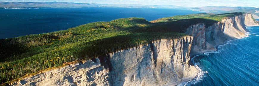
Forillon Park covers a total of 244.8 km2, including a narrow strip of marine area a little over 150 m wide (4.4 km2). Its history is as fascinating as its wildlife and plant life which includes Eastern Canada’s largest colony of Atlantic kittiwakes. As seen at the Grande‑Grave heritage site, commercial cod fishing prospered from the 18th century to the mid-20th century. Frequented by Aboriginal peoples for more than 4,000 years, Forillon is also the site of the only World War II coastal battery that is fully preserved and publicly accessible in Quebec, at Fort Peninsula. As impressive as the major role played by the Gaspé naval base in the Battle of the St. Lawrence from 1942 to 1944 is the discovery of a geological phenomena of easily visible fossils dating back 500 million years!
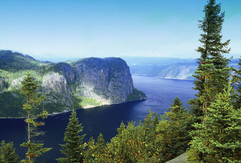
The scenery is so awe-inspiring! In this magnificent spot, nature used its colossal strength to create a fjord. There are so many things to see and do here in winter and summer alike. For example, you can head to Baie de Tadoussac to admire the extraordinary panorama of the boundless sea, but also to see hundreds of migrating birds. The scale of this migration gave birth to the Observatoire d’oiseaux de Tadoussac. The park is divided into three areas, as large as they are different: Baie-Éternité, Baie-de-Tadoussac and Baie-Sainte-Marguerite.
2017 is Canada’s sesquicentennial (that is to say, 150 years since Confederation), and to celebrate, Parks Canada is making access to national parks free for the year. substantial number of those national parks are on significant coastlines, and can be explored by boat. In this blog, the first of a series, we will provide information about National Parks on the Atlantic Coast.
Gros Morne National Park, credit to Sheldon Stone via Parks Canada
Midway up western Newfoundland, Gros Morne is a spectacular park on the Gulf of St Lawrence, facing Labrador.
Soaring fjords and moody mountains tower above a diverse panorama of beaches and bogs, forests and barren cliffs. Shaped by colliding continents and grinding glaciers, Gros Morne’s ancient landscape is a UNESCO World Heritage Site. Wander coastal pathways and beachcomb among sea stacks. Cruise the dramatic, sheer-walled gorge of Western Brook Pond. Spot moose and caribou. Hike to alpine highlands where Arctic hare and ptarmigan thrive on tundra, and explore the colourful culture of nearby seaside communities.
Terra Nova is in northeastern Newfoundland, north and west of the Avalon Peninsula and St. John’s.
A ragged-shaped oceanside park of sheltered inlets, islands, headlands, ponds, forests and bogs across 400 square kilometres (154 square miles), Terra Nova is perched on the northeast coast of Newfoundland, a three-hour drive from the provincial capital of St. John’s.
Though easily accessible by the Trans-Canada highway, it is a traditional island wilderness with abundant wildlife like black bears, lynx, ospreys, moose and the rare indigenous Newfoundland marten. Join a campfire sing-along, touch sea critters in a tank, enjoy live performances under the stars. Arrange a guided, interpretive park tour or explore the park on your own for a day or on a multi-day camping trip. Ten hiking trails range from kid and wheelchair-friendly nature strolls to challenging treks. Canoe or swim in Sandy Pond, kayak rugged shorelines. In winter, strap on snowshoes or cross-country skis for a backcountry experience.
PEI National Park extends over 65 kilometres of shoreline, including beaches, red sandstone cliffs and rolling sand dunes on the North Shore of Prince Edward Island in Atlantic Canada. Broad, sandy beaches draw crowds of day-trippers and campers throughout the summer. Meanwhile, extensive walking trails and boardwalks, as well as 20 kilometres of paved multi-use trail for cyclists, slice through varied coastal terrain, from saltwater marsh to Acadian forest. If the landscape seems storybook-perfect, there’s good reason. The park is also home to the 19th-century farmhouse immortalized in the novel Anne of Green Gables, now one of Canada’s most popular heritage places. Marvel at exotic dunescapes on the Greenwich peninsula. Camp, cycle and swim in the central Brackley-Dalvay region. Or just enjoy sun and sand and a glimpse of Canada’s literary past in Cavendish. With three distinct regions overall, PEI National Park brings together the best of Atlantic Canada.
Over 100 kilometers of rugged, wave-pounded cliffs, sheltered coves and long curving beaches mark the breathtaking journey to Cape Breton Highlands National Park. Every turn inspires a photograph. Some 26 hiking trails are carved out along the coastline, across mountaintops, and tucked into forested valleys. The Skyline Trail leads to a breathtaking headland above the Atlantic, where mountains meet sea. View the Chéticamp River valley from the gorgeous Acadian Trail. Lone Shieling is a walk through 350 year-old sugar maples. And Fishing Cove leads from mountain top to secluded ocean cove. You might spot a bear eating blueberries, or notice velvety moose antlers poking out between spruce and fir boughs. Overhead, bald eagles, hawks, and cormorants soar. Along the coast, catch a glimpse of plunge-diving northern gannets, bobbing seals, and, peeking out of the ocean waves, minke or humpback whales. Stay awhile to enjoy swimming, golf, ocean and beach-front camping, and of course, the warm welcome from the fishing communities you’ll pass along the way, where you can stop to take in a ceilidh or a yummy dinner of fresh local seafood.
Kouchibouguac National Park, credit to Parks Canada
Kouchibouguac National Park (New Brunswick) Park Website
Kouchibouguac National Park extends over 238-square-kilometres of Maritime Plain Natural Region along New Brunswick’s scenic Acadian Coast. This mosaic of salt marshes, peat bogs, freshwater systems, Acadian woodland and sandy beaches has long captivated guests, one generation to the next.
Hundreds of species of birds, dozens of mammals as well as amphibians, reptiles, rare plants and a wide variety of sea life inhabit this park, and the landscape welcomes exploration via its network of gentle hiking and cycling trails. Offshore, shifting sand dunes harbour the endangered piping plover and a colony of grey seals swims in the sea. Stargazing takes a unique perspective in this coastal Dark Sky Preserve. Kellys Beach is one of the region’s most popular summertime destinations. And in winter, the snowy side of Kouchibouguac invites soft adventure with cross-country trails and cosy warm-up huts.
Canada’s Atlantic Coast is a great place to cruise, and we hope you’ll explore the National Parks this summer. In the next blog in this series, we’ll explore the National Parks of the Gaspé Peninsula and the St Lawrence River
Now that Spring has sprung, it’s time for our annual Chat about Charts.
******
In the past, a number of blogs have been written about charts: what we carry, what we can order, and laws regarding charts. We’re proud to be a chart agent, providing Canadian Hydrographic Services charts, as well as charts from NOAA, Imray, Maptech, Richardson’s, NV Charts, and a number other organizations and companies. There continues to be some confusion over charts, specifically the legality of chartbooks and what is required.
Since this is something that confuses many people:
Small Scale = Large Area
Large Scale = Small Area
To put it another way, if you’re boating around Toronto Harbour, you’ll be required to carry chart 2085- Toronto Harbour. Chart 2077 (Lake Ontario West End) or 2000 (Lake Ontario general) would not be considered to have sufficient information.
The Canada Shipping Act requires most vessels to carry paper charts specifically, even if navigation will be done by GPS or on a computer. If you’re are going to be navigating, you should be carrying charts.
There have also recently been more questions about the legality of chartbooks, such as Richardson’s, Mapquest, and NV-Charts. These are not technically charts, but instead are very high quality photographs of charts. From discussions with representatives of various law enforcement agencies it is clear that there is no universal policy towards chart books. Anecdotal evidence suggests that also, reaction will vary from officer to officer. While the odds suggest that any individual person or boat may not be stopped by the Police or Coast Guard, and even if they were a chartbook such as Maptech or Richardson’s would usually be considered sufficient, they do not technically satisfy the legal requirement to carry charts in Canada.
The reality is that chartbooks such as Richardson’s are much easier to use on a chart table than a full paper chart, and that chartbooks are much more cost efficient than purchasing a full set of paper charts. We also understand that cost is a major factor for choosing to purchase chartbooks only, and not paper charts. What we would suggest is that our clients purchase a chartbook such as Richardson’s for their day-to-day navigation requirements, but also purchase the CHS charts they need to cover their usual cruising areas. To do so is more expensive, but it will cost far less than the fines for not carrying paper charts.
Charts are just part of what is required to be carried on board. It is always necessary to update charts or chartbooks with the Notices to Mariners. In addition, boats are required to have Chart One, Sailing Directions,Tide & Current Tables, the List of Lights, and Buoys and Fog Signals.
If you’ve talked to us about charts- you know that we place a strong emphasis on paper charts, whether they be CHS, NOAA, Imray, Explorer or anything else. Digital Charts cannot be denied, however. In Canada, it is still required to carry paper charts, even if you have digital charts. If you would like to purchase digital Canadian Hydrographic Service charts, we can absolutely provide them to you.
This website uses cookies to improve your experience while you navigate through the website. Out of these cookies, the cookies that are categorized as necessary are stored on your browser as they are as essential for the working of basic functionalities of the website. We also use third-party cookies that help us analyze and understand how you use this website. These cookies will be stored in your browser only with your consent. You also have the option to opt-out of these cookies. But opting out of some of these cookies may have an effect on your browsing experience.
This website uses cookies to improve your experience while you navigate through the website. Out of these cookies, the cookies that are categorized as necessary are stored on your browser as they are as essential for the working of basic functionalities of the website. We also use third-party cookies that help us analyze and understand how you use this website. These cookies will be stored in your browser only with your consent. You also have the option to opt-out of these cookies. But opting out of some of these cookies may have an effect on your browsing experience.
Necessary cookies are absolutely essential for the website to function properly. This category only includes cookies that ensures basic functionalities and security features of the website. These cookies do not store any personal information.
Any cookies that may not be particularly necessary for the website to function and is used specifically to collect user personal data via analytics, ads, other embedded contents are termed as non-necessary cookies. It is mandatory to procure user consent prior to running these cookies on your website.

 As he writes in All The Oceans: “My new office overlooked Coal Harbour, the downtown marina near Vancouver’s main commercial port: through the windows I had a clear view of boats moored at the Royal Vancouver Yacht Club marina, and beyond, of the snow-capped peaks of Cypress Mountain. It’s a dramatic but calming location, and I was looking forward to another phase of my life.”
 Ron wrote All The Oceans to inspire others. This latest chapter — settling in Vancouver, BC (where he eventually moved his office to Granville Island from Coal Harbour) was indeed a new start. After writing his memoir, promoting the book would lead him to revisit old haunts all over the world, reconnect with old friends and regale audiences on how he established an award winning international design company also including colourful nautical tales culled from a life of adventure.


 PROS
PROS